Current Research
My research integrates across disciplines of pedology, soil geomorphology, landscape ecology, Quaternary geology, remote sensing, and global change. My current work with the NRCS - National Ecological Site Team includes deploying a new Ecological Site format within the EDIT database to improve analysis, help integrate the ecological site information from the EDIT database with other SPSD databases (NASIS, CART, PLANTS), and develop machine learning methods for grouping soil properties relevant for Ecological Site/Group Class identification.
|
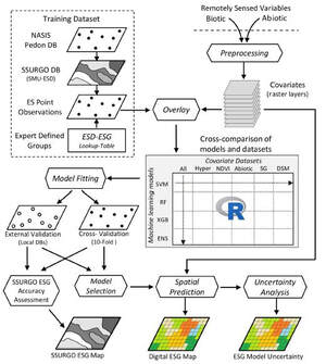
Landscape Ecological Classification
Working with the NRCS National Ecological Site Team, we used digital soil mapping approaches to map ecological sites in New Mexico, Texas, California, and Utah. Ecological site descriptions (ESDs) and their associated state-and-transition models (STMs) provide a classification and information system for defining ecological land units for management applications in the United States. |
|
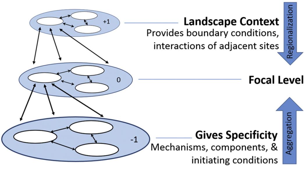
The NRCS Land Resource Hierarchy
The NRCS Land Resource Hierarchy is a hierarchical landscape classification system linking regional to local scales. While some scales are well developed, other scales lack organizing concepts, relationships, and definitions that allow for testing and revision. We synthesized a theoretical framework to assist agency updates to the hierarchy. |
Past Research
Prior to joining the National Soil Survey Center, I served as a Research Ecologist with USDA-ARS supporting National Cooperative Soil Survey research, including MLRA update, the provisional ecological site initiative, and developing the ecological group concept. During that time I also helped develop decision support tools for the LandPKS smart phone app; tested the BLM’s Assessment, Inventory, and Monitoring methods on soils across the North Slope, Alaska; and applied digital soil mapping techniques to identify ecological sites and group concepts in the Desert Southwest and California Central Coastal Rangelands.
The Land Potential Knowledge System App
LandPKS is a citizen soil science smartphone application designed to help land citizens assess land potential and access soil survey information. My research helped build multiple in-app modules and functions. Including an integrated Land Capability Classification (LCC) system, a rapid soil color tool (using smartphone camera and calibration card to identify soil color), a global (HWSD) and national (SSURGO) soil Identification module (SoilID, linking user entered soil morphology properties to soil survey data), as well as other refinements to the user interface / user experience and steps to improve data quality. For more information, visit: landpotential.org
LandPKS is a citizen soil science smartphone application designed to help land citizens assess land potential and access soil survey information. My research helped build multiple in-app modules and functions. Including an integrated Land Capability Classification (LCC) system, a rapid soil color tool (using smartphone camera and calibration card to identify soil color), a global (HWSD) and national (SSURGO) soil Identification module (SoilID, linking user entered soil morphology properties to soil survey data), as well as other refinements to the user interface / user experience and steps to improve data quality. For more information, visit: landpotential.org
|
SoilID
The global soil identification algorithm provides access to soil survey information based on location and user entered data. Our algorithm uses data mining and machine learning approaches to identify most likely soil class based on soil morphology. Supporting research has identified which key soil properties best link user data to soil class maps. |
|
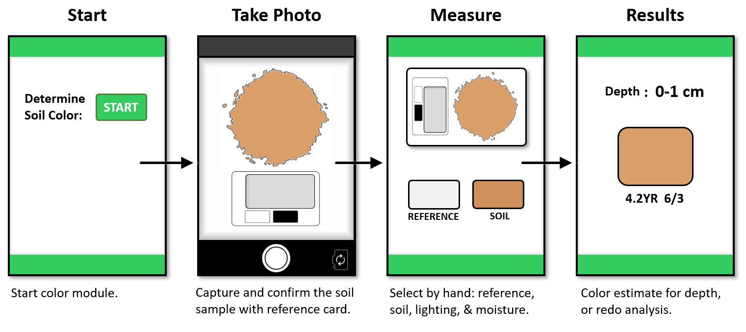
Soil Color Module
Color is one of soil’s most distinguishing characteristics. Soil color is primarily used to classify, interpret, and differentiate soils due to the strong relationship between color and important soil properties, including organic matter, mineralogy, moisture content, drainage class, and fertility. We developed the LandPKS SoilColor module to use the smart phone camera and an in-frame color reference to measure soil color. |
|
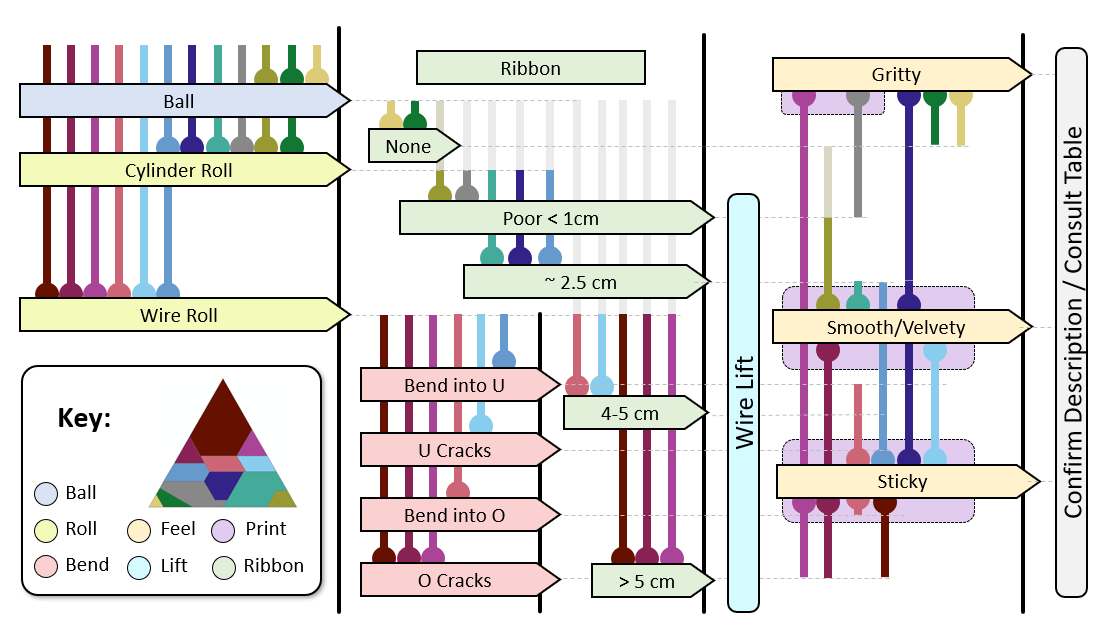
Improving Soil Hand Texture Using multiple classification criteria taken from two internationally accepted soil texture-by-feel field tests, we proposed a multiple criteria decision approach synthesizing texture-by-feel that could be used to improve citizen scientists field estimates of soil texture. Future work will be led by LandPKS scientists. |
|
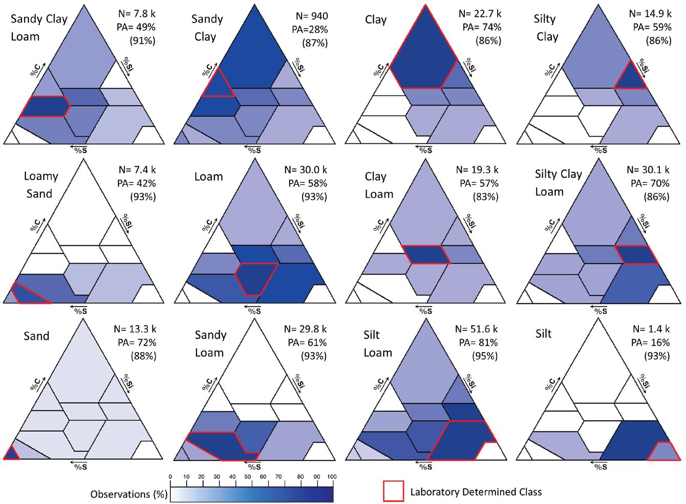
Soil Hand Texture Estimate Accuracy Soil texture-by-feel, or hand texturing, is considered a fundamental skill applied by natural resource scientists to rapidly classify soil resources and understand soil function and processes. We synthesized the accuracy of soil hand texture estimates for professional soil scientists and Citizen scientists. These findings underscore the need for all scientists to practice hand texture skills against known samples and to calibrate for localized variability in soil texture. |
|
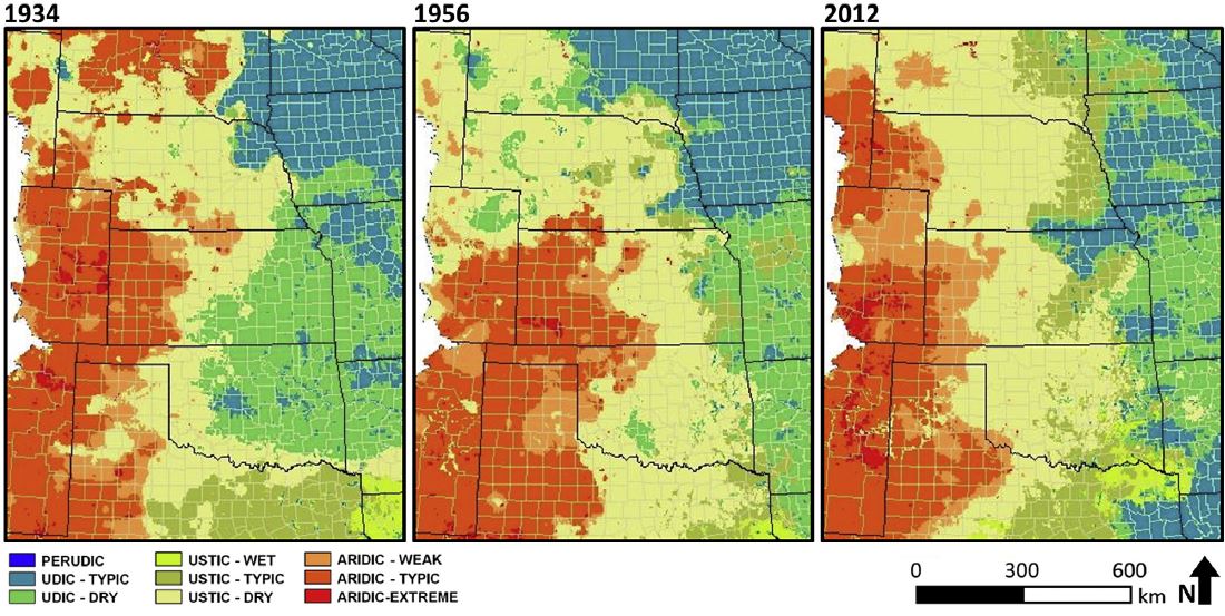
Modeling Temporal Soil Moisture Regimes
By modeling climate data from 1895 to 2015, we described soil geographic boundaries between the humid-eastern and arid-western regions of the North American Great Plains to understanding effects of short term climatic fluctuations on soil morphology and soil moisture classification. We showed climate variability is reflected soil properties, and that higher soil water holding capacity can dampen periodic short-term rainfall deficits while soils with lower water holding capacity can exhibit edaphic drought during normal years. |
